الخميس، 19 نوفمبر 2020

Twin Peaks for All: Survey Results

Twin Peaks for All: Survey Results
By Benjamin Barnett

Last month, the SFMTA and San Francisco Recreation and Parks Department released a survey seeking public feedback regarding five proposed roadway options for Twin Peaks Boulevard. San Franciscans responded to the survey, ranked support for each alternative and shared opinions about how the different options met their needs. 

The Twin Peaks for All survey was open for almost three weeks and received more than 1,700 responses. This number reflects the high level of interest for this San Francisco park and its future access.  

Survey Background
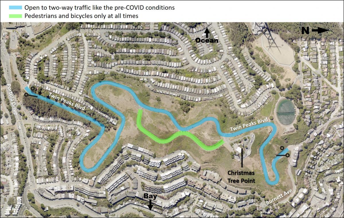
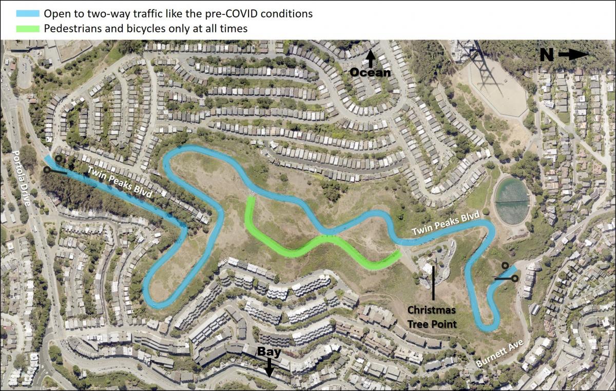
Map with a blue line indicating both the north and south gates open at all time for vehicles as were conditions pre-pandemic. A green line indicates the east side of the figure eight is reserved for pedestrians and biking. The west side of the figure eight is reserved for two-way traffic.
Conditions on Twin Peaks Boulevard between Portola Drive and Barnett Avenue before COVID street closures.  

The Twin Peaks Boulevard gates were closed early in the pandemic to reduce crowding at the lookout point parking lot. The gates were closed on the north, at Burnett Avenue, and the south, at Portola Drive. Since then, Twin Peaks Park use by hikers, joggers and people on bicycles has increased significantly, with an average of more than 800-weekday visitors and more than 1,100-weekend visitors.  

While the new park access configuration received support, there are also significant community concerns. Our goal with the new design proposals and survey is to find a solution that balances all the various needs of the community including people with disabilities, neighbors and everyone that enjoys this iconic park. 

Survey Options:

  1. Burnett Avenue - Burnett Avenue gate is open 24 hours, with parking and a vehicle turnaround available on Christmas Tree Point Road.  
  2. Portola Drive - Continue keeping the Portola Avenue gate open, extending the hours from noon to midnight daily.  
  3. One-Way Southbound - One-way, southbound vehicle traffic, from the north gate at Burnett Avenue to the south gate at Portola Drive. Reserve the northbound vehicle travel lane for people walking and bicycling.   
  4. One-Way Northbound - One-way, northbound vehicle traffic, from the south gate at Portola Drive to the north gate at Burnett Avenue. Reserve the southbound vehicle travel lane for people walking and bicycling.  
  5. Pre-COVID - Open both the north and south gates, as were conditions pre-pandemic. The east side of the figure eight is reserved for people walking and biking and the west side of the figure eight is reserved for two-way traffic.   

Overview of Results:
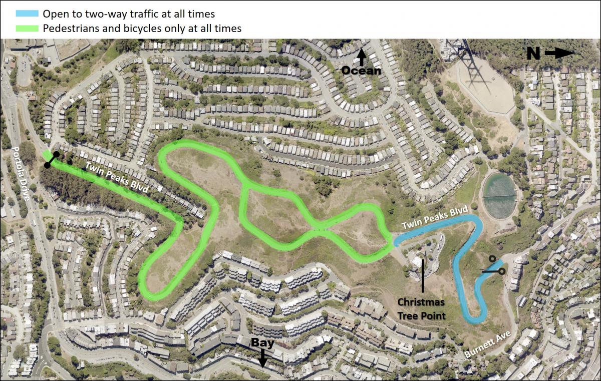
Map showing a blue line representing vehicle access from the Burnett gate up to the entrance of Christmas Tree Point parking lot 24 hours day. A green line indicates pedestrians and bikes only from the Portola Gate to the entrance to Christmas Tree Point. A green line indicates the east side of the figure eight is reserved for pedestrians and biking.
Map representing the Burnett Avenue Option, the most preferred option according to the survey. 

  • The Burnett Avenue Option was most preferred with 52 percent of people ranking it highest in comparison to the other four options 
  • The Pre-COVID Option was the most divisive of the five options, it ranked as the second most preferred with 30 percent but also most respondents ranked it as less preferred with 64 percent of the vote.
  • Mode of transportation to Twin Peaks was associated with responses, with visitors traveling by non-motor vehicular modes favoring the Burnett Avenue Option and visitors traveling by motor vehicular modes favoring the Pre-COVID Option 
  • Many respondents commented that they prefer some form of car-free space on Twin Peaks 
  • Survey respondents are concerned about sharing the road to the top of Twin Peaks with tour buses and motor vehicle traffic 
  • Crime, vandalism and litter are concerns associated with all options 

What We Learned from You

Many people who filled out the survey are regular visitors to the area; almost 50 percent of the respondents typically visit Twin Peaks one or more times per week with another 27 percent of people who visit once per month. People who took the survey tend to reside near the park. The highest percentages of respondents came from zip codes immediately adjacent to the park and of the more than 1,700 responses, 50 respondents were from outside of San Francisco. In total, 52 percent ranked the Burnett Avenue option as their preferred choice. The next closest preference was the Pre-COVID option, with 30 percent.  
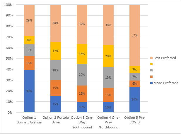
Bar graph showing Option 1 with 39% blue, 13% orange, 11% grey, 8% yellow, 29% peach, Option 2 with 15% blue, 15% orange, 18% grey,178% yellow, 34% peach, Option 3 with 10% blue, 15% orange, 20% grey, 18% yellow, 37% peach, Option 4 with 10% blue, 13% orange, 19% grey, 20% yellow, 38% peach, Option 5 with 24% blue, 6% orange, 7% grey, 7% yellow, 57% peach

Other data demonstrating Option 1 was the most preferred include:  

  • Trip frequency did not have an impact on preference, from the respondents stating that they rarely/never visit Twin Peaks to those visiting 1-4 times a week, Option 1 was preferred.  
  • Most respondents 64 years of age or younger preferred Option 1.Those 65 years of age or older preferred Option 5.  
  • Option 1 was the top preference across races/ethnicities.

More to Come

Access to Twin Peaks is important to San Franciscans and this was reflected by the large number of responses and the range of responses to the Twin Peaks for All survey. Responses reflected that both personal and property safety is important as is access to the beautifully scenic resource. For a much more detailed analysis of our survey data please visit our survey report.

SFMTA staff will continue to review the options, working with project stakeholders to develop a project that is feasible and meets the needs of the public based on the survey results. Staff will develop a final proposal to share with the community and present to the SFMTA Board of Directors for potential approval in the coming months.   Twin Peaks is a beautiful and unique destination for San Francisco residents and visitors alike and everyone should have the opportunity to enjoy it. For more information or to sign up for an email update, visit our project page.  


Published November 20, 2020 at 12:05AM
https://ift.tt/2IImjLb

الخميس، 12 نوفمبر 2020

Central Subway: Slowed by COVID-19 But Still Making Progress

Central Subway: Slowed by COVID-19 But Still Making Progress
By Phillip Pierce

The Central Subway is a transformational transportation project that will extend the T Third underground to Chinatown through some of the busiest and densest parts of our city. While this mega-project is nearing completion, we are unfortunately delayed a few months due to COVID-19 and other complexities. 

Before the pandemic, we anticipated that construction would be finished by the end of next month, with customers riding trains at the start of revenue service a year later. Our current projections put the completion of construction this spring and the start of service in the following spring of 2022. 

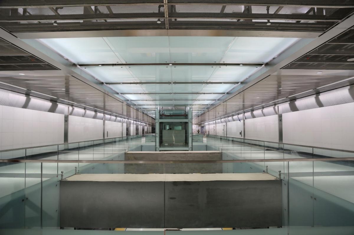
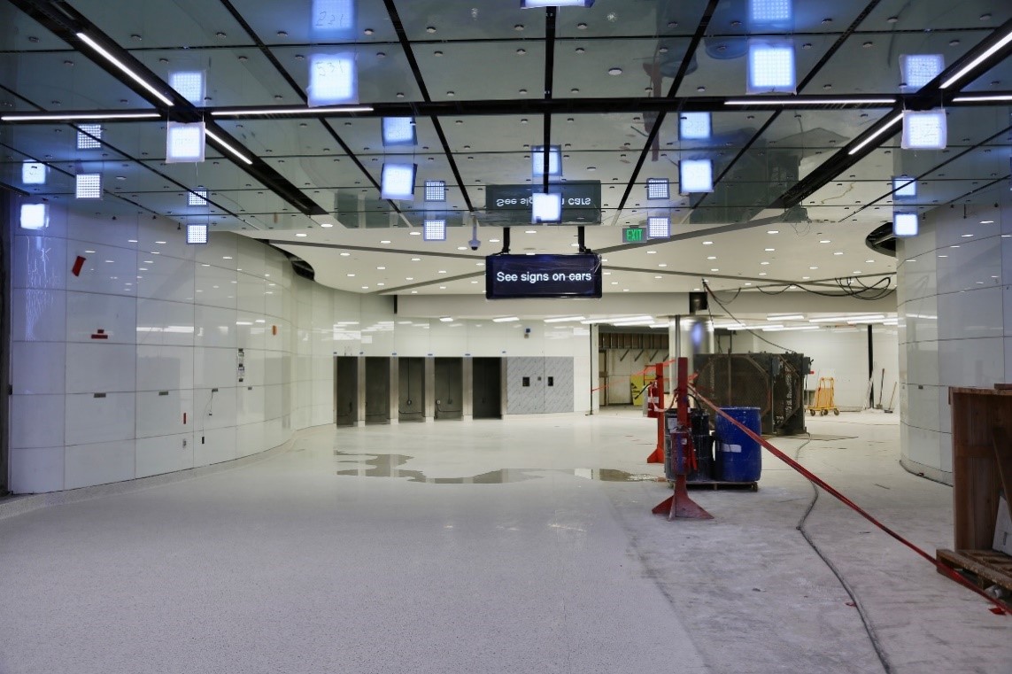
Picture of a corridor in the future Moscone Station

View of the sleek concourse at the Yerba Buena/Moscone Station. 

The main reasons for this delay: 

  • Moving to remote work and instituting necessary safety measures and procedures during COVID-19 

  • Quarantining multiple contractor crews when, despite safety measures, some of the team tested positive for COVID-19 

  • Difficulties and delays in getting materials from suppliers during COVID-19 

  • Ongoing design changes throughout the project due to the differing site conditions discovered deep underground 

These delays will likely have impacts on the overall project budget, and we are working closely with our construction contractors to get the project completed as safely and prudently as possible. 

Highlights and Making Progress  

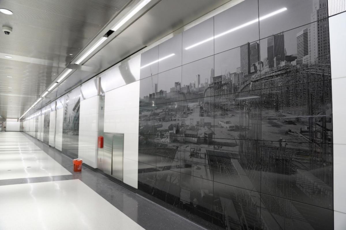
Granite etchings of construction photographs by artist Catherine Wagner installed at Yerba Buena/Moscone Station

Granite etchings of photographs by artist Catherine Wagner installed at Yerba Buena/Moscone Station 

Most importantly for our neighbors, the most disruptive construction is far behind us. The streets and sidewalks along Stockton Street in Union Square and Chinatown are reopened and most work is now deep underground. The last remaining closed street – one block of Washington Street in Chinatown - will be reopened around the end of the year.  

The vast majority of the project is now completed. The tunnels and tracks are done with crews now working on the final finishes, installing art and systems like automatic train control cabling, traction power and communications.  

We even added a ceremonial “Golden Spike” on 4th Street joining the new Central Subway railwith the existing T Third rail line. A golden spike was first used to celebrate when the rails from the east and west come together on the First Transcontinental Railroad – a tradition that many projects follow to this day. 

The project is a finalist for two International Tunneling Association Awards. The Chinatown–Rose Pak Station is a  "Project of the Year” contender. The Union Square/Market Street Station’s innovative design for the battered drilled shafts support system are also nominated.  

Crews have installed some of the public art  – including a kinetic sculpture at 4th and Brannon station, granite etchings inside Yerba Buena/Moscone (photo above) and a light installation at Union Square/Market Street.

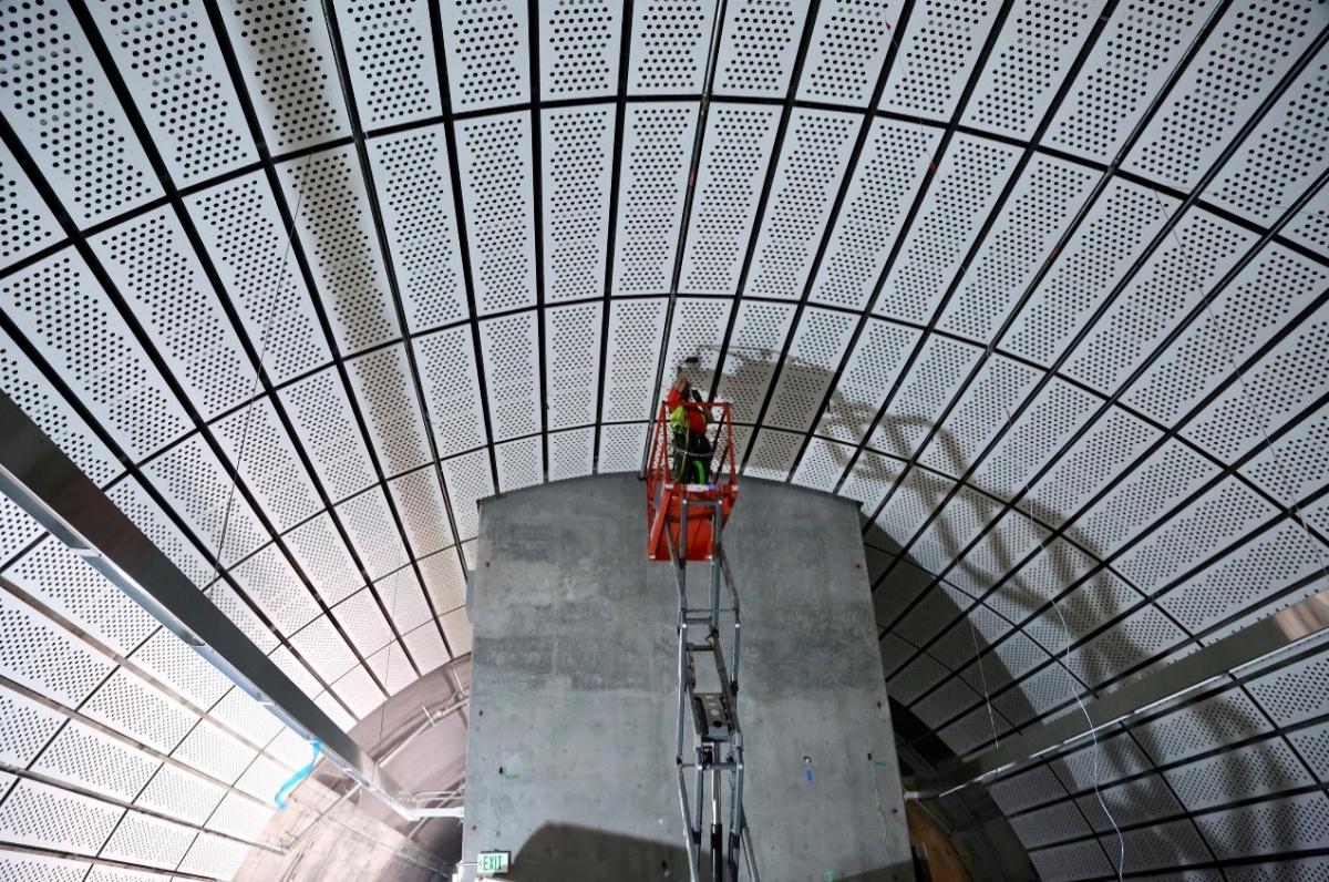
Some of the final decorative panels being installed at the platform level in Chinatown–Rose Pak Station

Some of the final decorative panels being installed at the platform level in Chinatown–Rose Pak Station 

Central Subway Facts 

Once in operation, the Central Subway will greatly reduce travel times and increase capacity along the congested Stockton Street and 4th Street corridor while enhancing connections to BART, Muni Metro, Chase Center, Oracle Park and Caltrain.  

The Central Subway route starts across from Caltrain at King Street, runs along 4th Street on surface, transitions into underground tunnels with a portal under the I-80 freeway, the tunnel crosses under the BART and Muni Metro tunnels beneath Market Street, and continues under Stockton Street to Washington Street. With an above ground stop in SoMa at 4th and Brannan, and subway stations at Yerba Buena/Moscone Center, Union Square/Market, and Chinatown – Rose Pak, the Central Subway will vastly improve transit access for the residents in areas of the city, such as Chinatown, that have limited transportation options. 

By extending the T Third line, the Central Subway will not only make new connections, but will also increase overall service in Visitacion Valley, the Bayview, and Dogpatch neighborhoods.

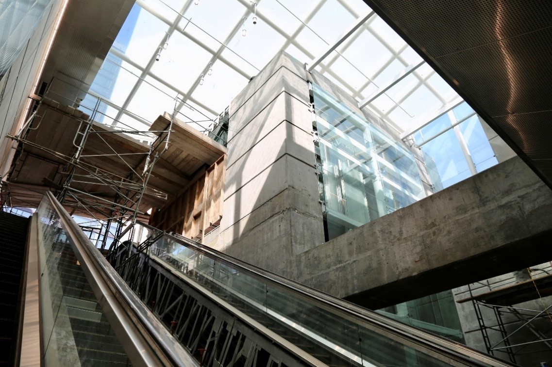
Lots of natural light and exposed concrete from the skylights for the entrance underground at Yerba Buena/Moscone Station.

Lots of natural light and exposed concrete from the skylights for the entrance underground at Yerba Buena/Moscone Station. 

Floors, ceiling panels, finishes and color-changing LED light art installation by Erwin Redl 

Floors, ceiling panels, finishes and color-changing LED light art installation by Erwin Redl 

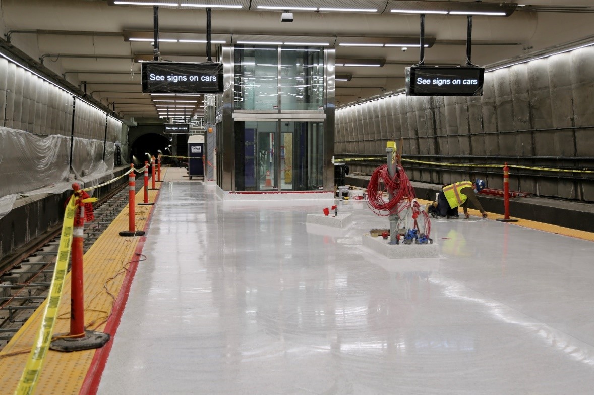
The platform at the future Union Square station

Platform level with finished floors and transit information signs up at Union Square/Market Street 


Published November 13, 2020 at 12:01AM
https://ift.tt/32G7Mq2

New Bayview-Hunters Point Bus Express Route Alternatives: Vote by November 15

New Bayview-Hunters Point Bus Express Route Alternatives: Vote by November 15
By Enrique Aguilar

In response to deep community engagement, the SFMTA's FY 2021-22 Muni Service Equity Strategy and the Southeast Muni Expansion Project recommended adding express service from the Bayview to Downtown. The disproportionate impacts of COVID-19 on people of color and low-income people has made fast-tracking this service even more important. We are asking for feedback to help us identify the future route of this crucial new service. 

This new express bus service aligns with our transportation priorities as we respond to and recover from the pandemic. Adding capacity to routes that help San Franciscans make essential trips and prioritizing neighborhoods with high concentrations of essential workers and those most impacted by the pandemic are goals in SFMTA’s Transportation Recovery Plan (TRP). This effort also minimizes travel time to reduce how long customers are in our vehicles, which are goals in our SFMTA’s Transportation Recovery Plan

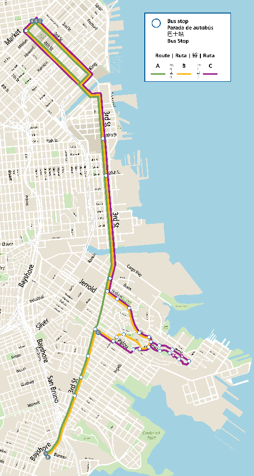
The proposed route options are estimated to take about 36 to 45 minutes one-way from end to end. The new express route from Bayview-Hunters Point would improve access to downtown, provide shorter travel times and reflect the priorities of neighborhood residents. 

  A map with the three route alternatives represented by options A,B and C.

Proposed route alternatives for Bayview Hunters Point Express 

How We Came Up With the Options 

Due to the pandemic, the SFMTA project team formed a virtual Working Group that was instrumental in shaping the three route options.  Members of the Working Group were: 

  • Alyssa Jones Garner (CCSF)  

  • Earl Shaddix (Economic on Third, EDoT)  

  • Emily Rogers-Pharr (PUC)  

  • Frank Martinez (BMAGIC)  

  • Juanita Washington  

  • Lyslynn Lacoste (BMAGIC)  

  • J.R. Eppler  

  • Nicole Christian (SFMTA)

  • Raina Johnson  

The Working Group identified key priorities, downtown destinations customers wanted access to and providing other critical information to help the project team engage the greater Bayview Community to make a final decision.   

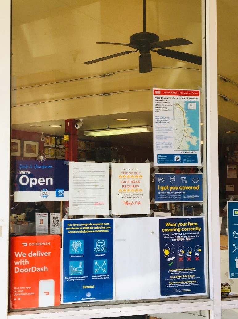
Photo of a storefront window, displaying the Bayview-Hunters Point Downtown Express Survey poster  

Signs posted at neighborhood businesses and Muni bus stops on 3rd Street. 

Please take our survey and vote on your preferred route alternative. The survey will be open until Sunday, November 15. Project staff will review feedback from the Bayview community and a final route identified. 

Bayview Express Survey (English) 

Bayview Express Survey (Spanish) 

Bayview Express Survey (Chinese) 

Bayview Express Survey (Filipino) 

Please visit the Bayview-Hunters Point Express page for more information. 


Published November 12, 2020 at 08:41PM
https://ift.tt/2K3K68A

الثلاثاء، 10 نوفمبر 2020

Can't pay your fare? We Can Help.

Can't pay your fare? We Can Help.
By Bradley Dunn

The COVID-19 pandemic has hit people hard.  Millions of people across the country have lost their jobs or lost their incomes.  When times are tough, even paying for the bus can be a challenge.  During times like these, the SFMTA has programs to help get you where you need to go, like Free Muni for Youth, Seniors and People with Disabilities, the Lifeline and Clipper START reduced fare program and our Essential Trip Card

Reduced Muni Fares for Low-Income San Franciscans 


Lifeline is a Muni-only monthly pass for customers on a limited income. Lifeline customers get unlimited access to Muni service for a calendar month at a 50% discount off the standard adult monthly pass price. Individuals with a gross annual income (before taxes) at or below 200% of the Federal Poverty Level are eligible to receive the Lifeline pass.

Federal Poverty Level:

Household Size 1 2 3 4 5 6
Annual Household Income $25,520 $34,480 $43,440 $52,400 $61,360 $70,320


Currently, Lifeline program applications and requests for replacement cards are being accepted online or by mail, and expired Lifeline passes have been extended until April 2022.  

Lifeline pass holders may also qualify for the Clipper START fare program, a new regional discount program that provides a 50% single ride fare discount to those who qualify for Lifeline, which is a great option if you qualify for Lifeline, but don't ride enough to need a monthly pass.  

You can apply for a Lifeline pass: 

Free Muni for Youth, Seniors and People with Disabilities 

This program provides low- and moderate-income youth, seniors and people with disabilities residing in San Francisco free access to Muni service when using a Clipper card.  

All San Francisco seniors, ages 65+, youth ages 5 to 18, and people with disabilities with a gross annual family income at or below 100 percent of the Bay Area median income level are eligible for the program according to the chart below:

Qualifying Income

Household Size 1 2 3 4 5 6 7 8

 Annual Household Income

$89,650 $102,500 $115,300  $128,100 $138,350 $148,600

$158,850

$169,100


You may apply by filling out the program application online or if you are unable to complete the online form, please mail a completed Program Application to: 

SFMTA Customer Service Center 
11 South Van Ness Avenue 
San Francisco, CA 94103 
ATTN: FREE MUNI 

Essential Trip Card 

The Essential Trip Card (ETC) – a discount program to help seniors and people with disabilities make essential trips in taxis during this crisis.  

The ETC will subsidize about two to three round trips by taxi per month for older adults (persons 65 and older) and people with disabilities. Eligible participants will pay 20% of the cost of a regular cab ride fare for essential trips.  The program uses taxis to take people on essential trips like going to the grocery store, pharmacy or another necessary medical trip during the shelter-in-place period. Customers who pay $12 will receive $60 value for taxi trips on a debit card.   

Together all these programs help make sure that every San Franciscan can access transportation during this difficult time. Even if you don’t qualify for one of these programs you can tell someone you know who would qualify for any of these programs and, make sure they apply. 


Published November 10, 2020 at 07:25PM
https://ift.tt/32uhDiu

الجمعة، 6 نوفمبر 2020

Parking Meter Pilot Coming to Dogpatch

Parking Meter Pilot Coming to Dogpatch
By Phillip Pierce

A small but exciting pilot project at parking meters on Indiana Street in the Dogpatch is starting Monday, November 9. For the past couple of years, all metered surface parking lots have been equipped with “pay-by-license-plate” functionality. Now we want to test the “pay-by-license plate” function for on-street parking meters as well.

The only change is that you’ll enter your plate number instead of a parking space number. Drivers may PayByPhone or at the multi-space paystation, just like always. Nothing will change about the forms of payment accepted: drivers will still be able to pay with coins, credit/debit or SFMTA parking card.  

Here are the benefits:

  • You can pay at any paystation on the block, even if it’s across the street. So drivers may head in the direction of their destinations, pay at the nearest meter, and be on their way. 
  • If you pay for parking but have to leave early, you may return to the same block and park without having to pay again, as long as you are within the original time frame you paid for.

For the SFMTA, we are using this pilot to test if the system can help:

  • Streamline enforcement, allowing parking control officers more time to focus on safety issues like double-parking and neighborhood concerns including Residential Permit Parking enforcement
  • Remove the need for space numbers and markings on the street that are costly to install and maintain
  • Allow for more vehicles to fit on each block when space markings are removed
  • Reduce the number of meters needed, freeing up sidewalk space and saving the cost of installation and maintenance

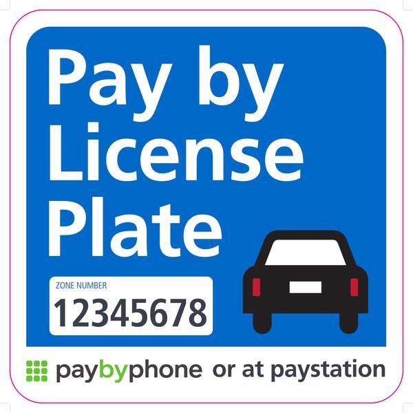
A "Pay by Phone" sign

Example of signs to be installed in the pilot area explain how to pay and provide a zone number.

Location and Privacy Details

The pilot is planned for Indiana in part because multi-space paystations already exist between Mariposa and Cesar Chavez streets on the on the following address blocks: 600, 800, 900, 1000, 1100 and 1500.  We plan to install permanent metal signs on the pilot blocks to indicate that customers must enter their license plate to pay, and temporary signs in the early stages of the pilot to notify drivers of the new payment process.

To connect payments with plates for enforcement purposes while preventing anyone from tracking specific plates, we will be masking license plate numbers in our database so that only a limited number of characters from each license plate will be stored.

How to Pay-by-license plate at a Paystation:

  • Enter license plate number at the closest or most convenient pay station
  • Choose the amount of parking time
  • Pay with coins, credit/debit or SFMTA parking card

How to Pay Using a Smartphone

  • Download or open the Pay-By-Phone app
  • Enter zone number found on nearby meters or pay stations
  • If it’s your first time in the app, enter your license plate number
  • Choose the amount of parking time
  • Pay with credit/debit or SFMTA parking card
  • You can extend your meter time through the app, if needed

How to Pay Over the Phone 

  • Call the number posted on signage
  • Respond to the prompts
    • Existing users will be prompted to enter the 4- or 5-digit location number, license plate number and parking time required
    • New users will be guided through a registration process
  • Pay with credit/debit or SFMTA parking card
  • Extend your parking by calling the same number

 How to Pay Online

  • Visit the PayByPhone website
  • Create a PayByPhone account and use it to pay for parking.
  • Enter location number, license plate number, and amount of parking time
  • Pay with credit/debit or SFMTA parking card
  • Extend your parking by visiting the website again


Published November 06, 2020 at 09:24PM
https://ift.tt/36fN8y5

الخميس، 5 نوفمبر 2020

Vision Zero - Safety It’s Your Turn: Funding Opportunity for Community Based Organizations Around Traffic Safety Education and Outreach

Vision Zero - Safety It’s Your Turn: Funding Opportunity for Community Based Organizations Around Traffic Safety Education and Outreach
By

In San Francisco, left-turns are one of the top three crash factors in severe and fatal collisions for people walking and biking. In 2019, almost 40% of all traffic fatalities in the city involved a left-turning vehicle. To encourage safer behavior, the SFMTA is announcing the Vision Zero Safety – It’s Your Turn Community Grant opportunity for community-based organizations (CBO) to share traffic safety information that compliments street changes.

Safety - It's Your Turn campaign logo

Speed is the most dangerous factor when turning left. At 30 mph, a person is twice as likely to die if hit by a car. That’s why in October 2020, the SFMTA announced (pdf link) the Left-Turn Traffic Calming Projects and the Safety—It’s Your Turn campaign. Left-Turn Traffic Calming Projects place traffic calming devices such as painted safety zones, delineators, and left-turn guide bumps at street intersections in order to reduce the speed at which a car can make a left-turn.

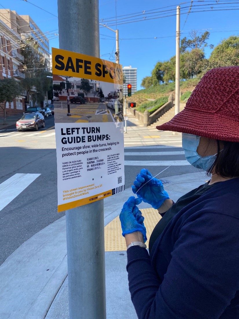
The Safety—It’s Your Turn campaign is a traffic safety education campaign designed to raise awareness about the dangers of unsafe left turns, to promote better driving behavior and to encourage walking and bicycling. In October, street teams began conducting door-to-door merchant and resident outreach, car-to-car outreach and posting Safe-Spot posters around the Left-Turn Calming Projects.

An outreach worker puts up a poster.

An outreach worker puts up a poster Safety – It’s Your Turn poster. 

To complement the Safety—It’s Your Turn campaign’s citywide outreach starting January 2021, the SFMTA is announcing a grant opportunity for community-based organizations (CBO) to conduct traffic safety education and outreach within the community. The Safety – It’s Your Turn Community Grant includes up to three $20,000-$30,000 grant awards and up to four awards between $10,000-$20,000.

The SFMTA recognizes that CBOs are often closer to the communities they serve, have a better understanding of community needs and are better positioned to share relevant health and safety messaging with their communities. The SFMTA is awarding up to seven funding opportunities to CBOs in the form of community grants to share information related to safer left-turn driving behavior and encouraging walking and bicycling with historically underserved communities in San Francisco. CBOs currently providing emergency COVID-response and serving Black, Indigenous, People of Color, the disabled, the unhoused, elderly, youth and/or non-English speaking communities are encouraged to apply. Transportation experience is not necessary!

Community Grants Key Dates

  • Informational Meeting: November 10, 2020. Register here for the Information Session!
  • Application Deadline: November 20, 2020
  • Applicants Notified: December 2020
  • Grant Kick-Off Meeting: January 2021
  • Project Implementation January 2021-March 2021Final Project reporting: April 2021

More information on the grant application, terms and FAQ can be found here.

For any questions regarding the Safety It’s Your Turn campaign or the Community Grants, please email VisionZeroSFLeftTurns@sfmta.com


Published November 06, 2020 at 02:20AM
https://ift.tt/3p1vsyF

الأربعاء، 4 نوفمبر 2020

Slow Streets Takes it to the Streets

Slow Streets Takes it to the Streets
By

As the Slow Streets program develops plans for its fourth phase, the team is headed directly to historically under-served neighborhoods to conduct outreach. Most of the current Slow Streets have come from community suggestions from the over 6,500 responses to our online questionnaire. For this next phase, the program will go to those neighborhoods that don’t yet have Slow Streets to see if there is interest and support.

Slow Streets Graphic
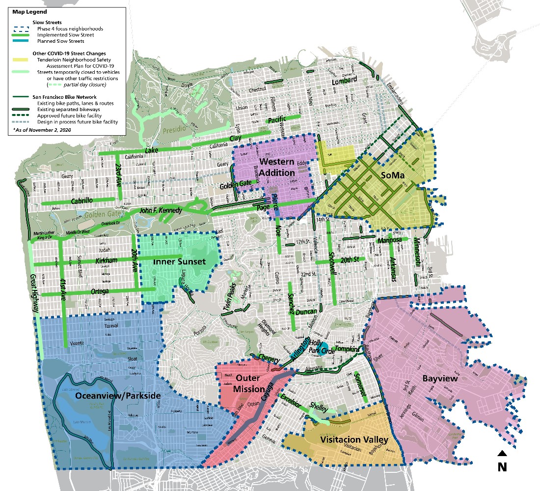
Map of Slow Streets showing the seven neighborhoods where conversations with residents will determine if there is interest and support for Slow Streets corridors there.

Looking at the questionnaire responses received, we heard a lot from residents in some neighborhoods and very little from others.   While there were many great suggestions for Slow Streets, including some that aren’t yet implemented, we want to improve the process for a more equitable citywide program that is representative of the city as a whole.

From Tuesday, November 10 through Thursday, December 10, the Slow Streets team will take to the streets and engage residents on a neighborhood planning level for the next phase of Slow Streets. The team will be working with stakeholders in:

  • Western Addition
  • SoMa
  • Inner Sunset
  • Oceanview/Parkside
  • Outer Mission
  • Visitacion Valley
  • Bayview

Throughout the month staff will talk to residents in each of these neighborhoods to share what Slow Streets are and find out about whether residents would like Slow Streets in their community. Additionally, the SF Parks Alliance will help broaden our outreach and engage with neighbors that we’ve yet to hear from, utilizing local knowledge to empower communities and develop solutions that respond to the unique needs of each neighborhood. Several suitable candidates for Slow Streets in each neighborhood have been identified preliminarily, and we’ll be collecting feedback through area-specific online questionnaires, community meetings, limited physically distant on-the-ground outreach with residents and live online office hours. Following the month-long community input process, SFMTA staff will prepare corridors for review and approval of the fourth phase of Slow Streets at the MTA Board of Directors in early 2021. For more information on our Slow Street Program please visit our project page.

What is Slow Streets?

Slow Streets is a temporary, emergency response program designed to limit through traffic on certain residential streets and allow them to be used as a shared space for people traveling by foot and by bicycle. Throughout the city, 25 corridors have been implemented as Slow Streets. On these Slow Streets, signage and barricades have been placed to minimize through traffic and prioritize walking and bicycling. The goal of the Slow Streets program is to provide more space for physically distant essential travel and exercise during the COVID-19 pandemic.


Published November 05, 2020 at 01:32AM
https://ift.tt/3k7aFpT

الجمعة، 30 أكتوبر 2020

New Twin Peaks Proposals: Survey Open Until November 3

New Twin Peaks Proposals: Survey Open Until November 3
By

Map with a blue line indicating both the north and south gates open at all time for vehicles as were conditions pre-pandemic. A green line indicates the east side of the figure eight is reserved for pedestrians and biking. The west side of the figure eight is reserved for two-way traffic.

The Twin Peaks Boulevard gates were closed early in the pandemic to reduce crowding at Christmas Tree Point lookout parking lot. Since then, Twin Peaks Park use has increased significantly among people walking, rolling, hiking, jogging and bicycling, with an average of over 800 visiting each weekday and over 1,100 on weekend days.

While the new park configuration received support, it also resulted in community concerns regarding accessibility for people with disabilities and negative neighborhood impacts. In an attempt to address concerns, local roadway access is now available via the Portola Drive south gate daily between 6:00 p.m. and midnight. 

The SFMTA is working with the community and other city departments including Recreation and Parks, the Police Department and Public Works, on new ideas to ensure access that balances the needs on Twin Peaks.

Project Goals:

  • Restoring access to the viewpoint, especially for people with disabilities 
  • Providing a space for people walking and rolling that allows for physical distancing 
  • Reducing negative impacts by park users on neighbors 
  • Retaining the extraordinary increase in new park users by maintaining safe, continuous routes for those traveling on foot, bicycle and assistive mobility devices

SFMTA is seeking feedback on five alternative designs for Twin Peaks. Please explore the designs and provide input below with our survey. The survey will close November 3. Community feedback will be analyzed and final proposals shared with the community. 

Twin Peaks Survey

Twin Peaks Survey (Chinese)

Twin Peaks Survey (Spanish)

Twin Peaks Survey (Tagalog)

For more information on Twin Peaks please visit our Twin Peaks For All project page.


Published October 30, 2020 at 05:48PM
https://ift.tt/3jFebax

الأربعاء، 28 أكتوبر 2020

Moving Better Market Street Forward

Moving Better Market Street Forward
By

This blog is co-authored by SFMTA Director of Transportation Jeffrey Tumlin and San Francisco Public Works Acting Director Alaric Degrafinried.

Less than a year after car-free Market Street closed the area to private vehicles to improve safety and transit performance and set the stage for construction of Better Market Street, city agencies involved in the project must adjust plans for the first phase of project construction from 5th to 8th streets.

Our plans for the project need to change not only because of the impact on the local economy and our department budgets due to COVID-19, but also because of the greater-than-anticipated success of car-free Market Street. When private vehicles were removed from Market Street, transit became up to 12% faster and the number of people biking increased by 25% – over 800 people per hour at peak. The original designs for a new sidewalk-level bikeway would not have enough capacity to keep up with the updated demand of people biking on Market Street.

The COVID-19 pandemic also required us to revise our plans because it is not only a health crisis but is also devastating the economy, including local businesses and the capital funds of all city agencies involved in this project. As local businesses work to recover, we need to minimize construction disruptions – especially on the sidewalks in front of their stores.

Given the economic challenges and changing demands we now face in San Francisco, our departments came together and made the tough decision to adjust the design for Better Market Street in order to move the project forward. As a city, we remain committed to working with our community partners and delivering the Better Market Street project to make this vital corridor safer, more resilient and more inviting for all.


Funding and Time Constraints

The full project from Octavia Boulevard to Steuart Street was estimated to cost over $600M when the project was approved. By the time the COVID-19 pandemic hit, the city had secured only approximately $200M to plan, design and construct the full project. The funding gap was going to be a challenge even before the current financial crisis decimated our department budgets. By postponing major changes to the sidewalks and limiting certain infrastructure upgrades, we expect to save over$60M for Phase 1 between 5th and 8th streets alone.

Construction must start in early 2021 due to the requirements of a federal BUILD Grant providing key funding for building the project. These grant funds are needed now more than ever so we must proceed as quickly and thoughtfully as possible to get started.


Goals and Plan for Phase 1 Construction: 5th to 8th Streets

The project goals remain to improve safety, transportation, accessibility, infrastructure and revitalize Market as the city’s preeminent civic space and ceremonial street. The first phase of construction between 5th and 8th streets is focused on four key components:

  • Create a bike facility that will safely accommodate more people on bicycles
  • Build new accessible boarding islands to improve the customer experience, transit functionality and capacity, and new wider curb ramps to upgrade sidewalk accessibility
  • Upgrade and replace aging infrastructure like the rails, overhead lines, traffic signals, sewer and water lines, and repave the street
  • Replace unhealthy trees and new street furnishings but postpone replacing the brick sidewalks or changing the sidewalk to minimize disruptions directly in front of local businesses


Changes for People Biking

The original sidewalk-level bikeway design is too expensive and won’t have enough capacity. It was designed to accommodate 2015 levels of people biking – half the people biking in 2020 pre-COVID, let alone the increases we expect to see in the future. As in our original plans, we remain committed to reducing conflicts between Muni and people on bikes.

Our new plan is to move all Muni buses to the center lane, reserving the curb lane for bikes to share with paratransit, taxis and commercial vehicles (note: Uber/Lyft are considered private vehicles and are not allowed on Market Street). By removing curbside transit stops we will also eliminate conflicts between buses and people on bikes.

The curb lane will have updated bike priority markings on the pavement, speed tables to discourage speeding and a raised buffer between lanes to discourage vehicles from changing lanes. Loading restrictions in the morning and evening peak commute hours continue to limit delivery vehicles and conflicts during the busiest times on Market Street.

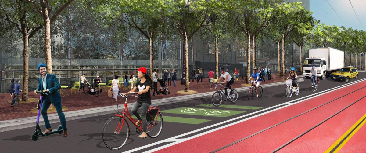
Better Market Street bike lane graphic

Graphic: The first phase of Better Market Street includes a bike-priority curb lane and center Muni-only lane. San Francisco Public Works


Accessibility and Transit

All Muni routes on Market Street between 5th and 8th streets will shift to the center in a Muni-only lane – taxis and other buses are not allowed. To reduce crowding for customers waiting, we plan to build new boarding islands that are twice as big as the current islands. The new islands at UN Plaza and at 6th Street will have new shelters with seating, be fully accessible, and include wheelchair ramps for F-line service.

New wider sidewalk curb ramps at intersections and across from boarding islands will also make the sidewalk more accessible.

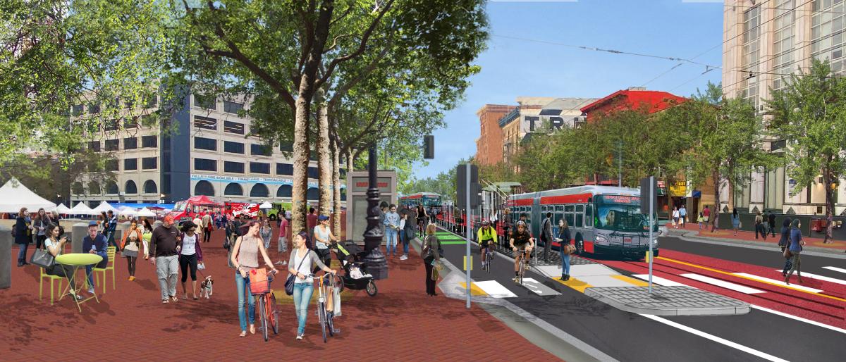
Better Market Street new Civic Center area graphic

Graphic: Accessible center boarding island at UN Plaza. San Francisco Public Works  


State of Good Repair

Better Market Street will replace the worn-down rails, BART grates in the street, and traffic signals, and fully repave the road. The project team plans to replace some water and sewer pipes that have reached end of life and reline others to extend their life. Lastly, some transit infrastructure is worn out and in need of replacing, including the traction power systems that provide electricity to vehicles, overhead lines and switches.

Plans for Better Market Street also still include construction of the F-Loop, which will improve Muni service with new rail along McAllister Street and Charles J. Brenham Place allowing the F Market & Wharves streetcars to return to the waterfront for faster service without limiting access to the Castro.


Postponing Major Sidewalk Work

By not widening the sidewalk, replacing light and overhead cable system poles and other utilities, or the red brick, we can significantly reduce immediate costs as well as disruptions to businesses along the street. We plan to revisit this segment between 5th and 8th streets further down the line when conditions improve and work with building developers to make sidewalk upgrades part of their work.


Public Meetings

We recognize that these are big changes. We are actively meeting with project stakeholders and city partners. We will hold a virtual open house from November 2 – 13 that will be available online for the public to visit. We will also hold virtual public meetings on November 4th at noon and November 9th at 4:30pm to share project details and hear feedback. For details please visit the Better Market Street project website.


Published October 28, 2020 at 11:59PM
https://ift.tt/35I8m7l

الاثنين، 26 أكتوبر 2020

City Project to Improve the 28 19th Avenue Bus Line

City Project to Improve the 28 19th Avenue Bus Line
By Enrique Aguilar

As part of the 19th Avenue Combined City Project, the SFMTA will implement transit priority and safety improvements for people walking along the route of the 28 19th Avenue. The improvements will make it safer to walk, remove stops to make transit service more reliable, and enhance customers’ experiences—on and off the bus.  

As part of the project, seven Muni stops were removed between Irving Street and Ocean Avenue on the 28 19th Avenue bus line to improve transit reliability. Removing closely spaced stops will help to reduce delays for the 28 19th Avenue line while preserving bus stops within a block of each removal to minimize impacts to people with limited mobility. Please visit our website for more details about these stop changes, which took effect on October 17.  

The project includes transit bulbs that allow Muni vehicles to stop for passengers without having to pull out of traffic. It will also widen the sidewalk at corners by installing pedestrian bulbs along 19th Avenue and modify traffic and pedestrian signals to give people who walk more time to cross the street.  

The SFMTA Board approved the project, including these stop changes, after community engagement and feedback in 2015.  

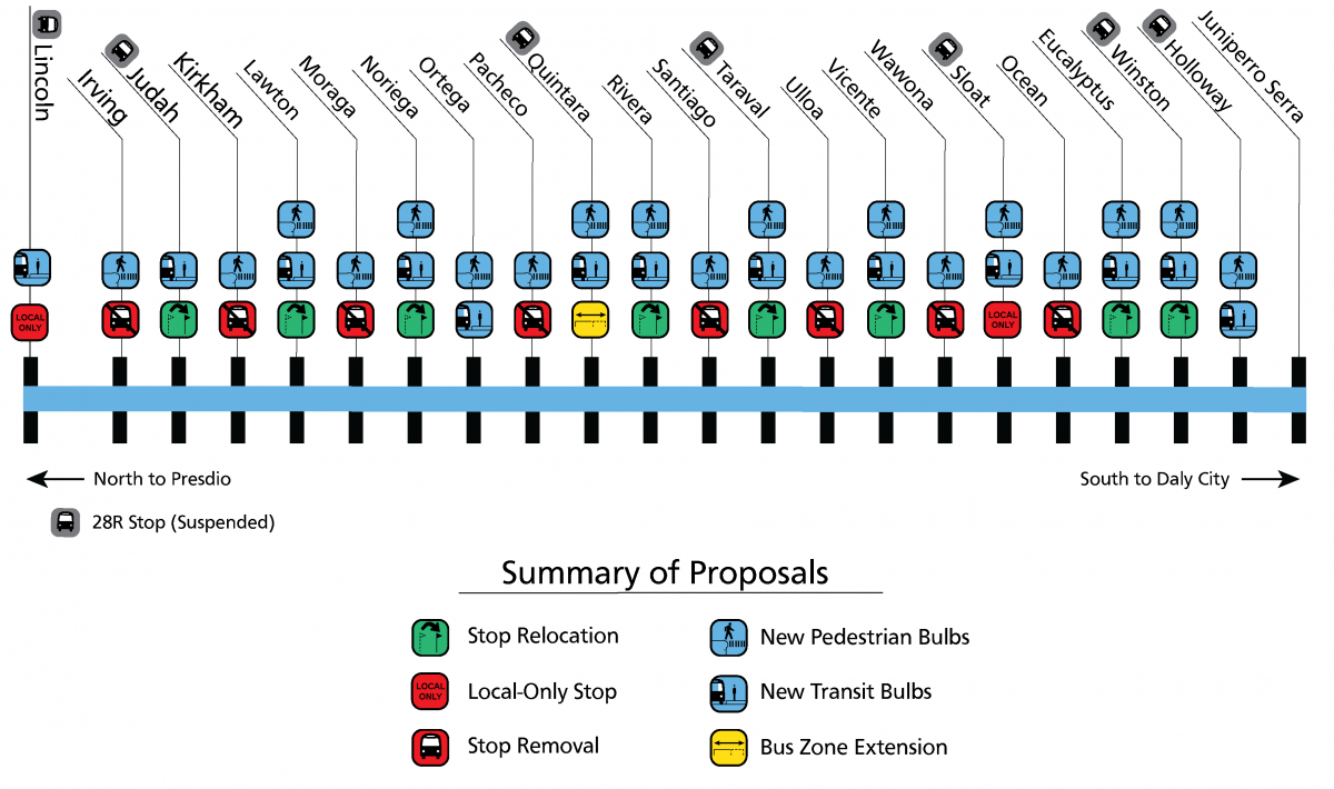
Diagram summarizes proposed improvements, which include transit bulbs at 13 intersections, pedestrian bulbs at 19 intersections, stop relocation at eight intersections including udah, Lawton, Noriega, Rivera, Taraval, Vincente, Eucalyptus, Winston. It will make bus stops far-sided to take advantage of Transit Signal Priority, local stop only at two intersections, and bus zone extension at one intersection.

Diagram of 28th the 19th Avenue Rapid Project improvements (note: stop removal on 19th at Irving is still under review) 

The transit improvements are just one part of the combined project that will also include water main and sewer replacement and rehabilitation and Auxiliary Water Supply Service for emergency fire fighting. This project will be followed by Caltrans repaving of 19th Avenue from Holloway Avenue to Lincoln Way. 

San Francisco Public Works will lead construction, beginning in Fall 2020 and be completed in 2023. Project work will be completed in four segments to minimize construction impacts during its 27-month duration. The first construction segment from Lincoln Way to Noriega Street on 19th Avenue is anticipated to begin in November.  

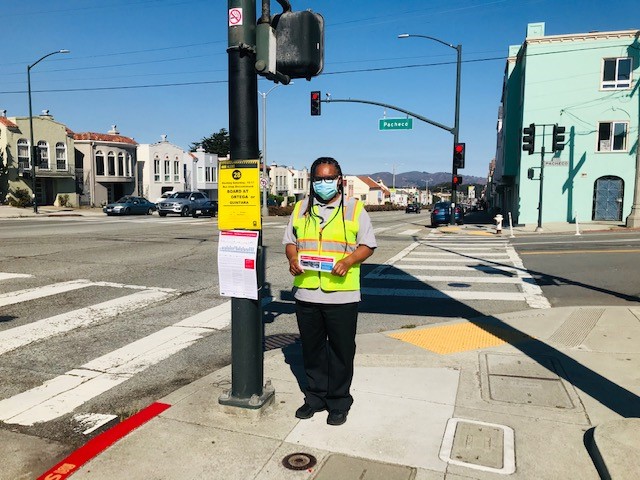
In preparation for stop changes this month, project staff has mailed over 10,000 postcards to residents near the project area, posted multilingual signs at every intersection, and briefed district supervisors for District Three, Four and Seven. Transit Information Program (TIP) staff along 19th Avenue were present during the first six days of these stop changes taking effect to help customers find alternative stops, provide project information and answer questions.  

TIP staff helping 28 19th Avenue customers find alternative stops 

TIP staff helping 28 19th Avenue customers find alternative stops 

Find additional information about the transit reliability and pedestrian safety components of the project at SFMTA.com/28Rapid. For the overall project information, please visit sfpublicworks.org/19th-Avenue.


Published October 26, 2020 at 10:47PM
https://ift.tt/3ow9lQI